Projects
How many statues in the Perth City Center
Mapping statues on streets of Perth City Center (Western Australia)
Abstract
The project intends creating a georeferenced spatial database of on street sculptural assets within the Perth City Center. Objective also includes creating web application for visualization purposes.
Results
The outcome of this projects are web application of an sculptural assets for the touristic and leisure purposes and the fully attributed geospatial vector features dataset in shape file format
Introduction
Perth City Center is the most touristic and business place in Western Australia and offers all sort of public infrastructures. In order to properly manage city’s resources that have been provided with huge capital investment there is need to keep inventory of these facility.
This project particularly focuses on the sculptural assets inventory within the Perth City Center.
Study area and data
Perth is the capital and largest city of the Western Australia (WA). It is named after the city of Perth, Scotland and is Australia’s fourth-most populous city, with a population of 2.14 million living in Greater Perth. The metropolitan area is on the Swan Coastal Plain, land area between the Indian Ocean and the Darling Scarp.
Perth City Center is located between New Castle St to the North, Victoria Ave to the East, Elizabeth Quay to the South and Mitchell Fwy to the West. It is is approximately 2.8 kilometers sq.
- The following asset groups included in the project:
- Street art installations
- Statues, monuments, sculptures and sculptural complexes
- On-wall bas-reliefs, murals and plaques
Typical attributes includes Unique Asset ID, Name, Artist name, Year build, Type, Material, Comment, Photo, Date and Location
This project requires mapping and collection of detailed asset data for roads and streets within Perth City Center. Field data collection utilized QFild mobile software.
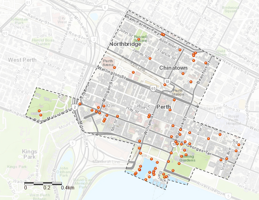
Image map indicating the location of study area. (Source of imagery: Google Roads)
Method
This inventory assets project does not require the accuracy within 1cm. The filed capture data accuracy up to 3-5 meters will serve this project perfectly. Hence, there is no need for this project use a RTK for differential correction (GNSS receiver).
Equipment and requirements
- Cellular-enabled smart phones or tablets with an integrated GPS chipset manufactured by companies like Qualcomm, Broadcom, CSR and others. Collector is supported on Android, iOS, and Windows devices.
- QField mobile app integrated with QGIS open source software.
- Esri Collector also could be used for the field collection but it requires an ArcGIS organizational account (ArcGIS Online paid subscriptions or ArcGIS Enterprise).
This project used QField mobile application to collect field data. Working functionality is the same as Esri Collector, but preparation process much easier and allows to skip many steps required by Esri. Field data could be exported as a shape file in order to work with ArcGIS or other GIS software.
Preconditions
-
QField or Esri Collector allow to create an asset inventory, record observations, and perform inspections in the field. Mobile workers use the app in the field, collecting locations and filling out forms. The information mobile workers can provide is determined by the map they work with, and map should be defined before field data capture.
- In desktop GIS software create an editable hosted feature layer to hold the newly added assets and observations during the collection project.
- Define the fields and prepare form design, enable attachments to allow mobile workers to attach photos.
- Add none editable reference, configure search and configure the form.
- Test the map in the field before start to collect data.
- Prepare the mobile routes plan.
The below mentioned preconditions have to be fulfilled before the Field Surveying:.
Influences on Data Quality
In the open sky, GIS mapping-enabled devices give approximately 90% confidence of the positions collected fell within 3-8m.
- Vegetation coverage. In canopy conditions where significant multi-path interference encountered results expected considerably worse.
- GPS accuracy depends on a mobile device. Enable both cellular service and Wi-Fi on the device and connect to a Wi-Fi signal if the device does not do so automatically to increase the accuracy of the device position.
Data processing and Results
Once the project’s field data were collected, the attributes were synchronized with feature layer in QGIS. The feature layer in shape file format could be downloaded from here.
One of the visual outcome of this project is the web map tour application. Esri ArcGIS online was utilized for this purpose.
Creating web application
The easiest way to create web application with ArcGIS online public account is to use the Story Map option.
-
Main steps of this workflow are:
- Upload all photos/videos related to feature layer in any public host.
- In Desktop GIS Software calculate the latitude and longitude of points. In QGIS ran Export/Add Geometry Columns.
- Export attributes to CSV file
- Use this CSV file when creating the web map application. The ArcGIS online web application builder will require latitude, longitude, title, description and photo location for the tour points, which will be derived from CSV file.
Conclusion
Assets inventory and management always was the one of important task of the City Council in any country and city.
Nowadays the advances of GIS technologies, significantly increased the functionality and life cycle of the asset, due to possibility of delivery highly detail and fully attributed asset geodatabase.
However, it still remain very time consuming and expensive process.The core of suggested method is combination of utilization based map from open sources and mobile mapping using filed collector software on GPS-enabled mobile device.
The working procedure is also very simple, and the results data collection can be directly applied to database.
The proposal method suggests use iOS and android devices with QField field collector, but it should be noted there are many other filed collection GIS app are available.